


By Ar. Humaira Nazir – Assistant Professor, Sir Syed University of Engineering and Technology
For Pakistan’s tourist business, globalization presents incredible prospects. Pakistan is privileged to have a variety of landscapes and regions inside a single nation, making it a rich source of all kinds of tourist sites. Pakistan’s topographical variety includes deserts, glaciers, rugged terrain, sandy beaches, landlocked mountains, and peaks with four different seasons. Its long history has given birth to ancient civilizations like Mohenjo-daro, Mehrgarh, Harappa, and Taxila. The best thing about this country is not just the ruins of ancient civilizations and stunning scenery, but also the legends associated with these spellbinding locations. This lovely nation contains many undiscovered gems with enthralling and thought-provoking mythologies that need to be revealed and communicated.


Baluchistan is an area that has many undiscovered gems. “Land of Beauty” is a perfect description of the province of Baluchistan. It makes up 42% of Pakistan’s total land area and is the biggest of the four provinces geographically, with 347,190 km2. Due to the steep terrain and water shortage, the population density is quite low. Baluchistan’s eventful past, which dates back to the Stone Age, is visible in the region’s geology, which is represented by a complicated sedimentary pattern of deposits from many eras. At Mehrgarh, a 9000-year-old civilization has been discovered via recent studies and archaeological digs. The distinctive transition from a hunting-gathering to a settled existence was introduced for the very first time in the history of mankind at Mehrgarh, where the human settlement pattern was unprecedented and unique. Additionally, the finding of utensils in this region that are similar to those found in other historical sites in Pakistan, like Mohenjo-Daro in Sindh, Kalibangan in India, and Nisa in Turkmenistan, has led archaeologists from all over the world to think that human communication in the region of South Asia began in Balochistan.
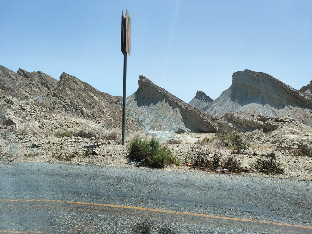
Its northeastern part is dominated by the Sulaiman Mountains, and the Bolan Pass is a natural entry point into Afghanistan that leads to Kandahar. A large portion of the province is barren desert terrain south of the Quetta region, with a few inhabited villages scattered throughout, primarily around rivers and streams. Makran is the name of the region in the south. Kalat is the name of a region in the province’s middle. The coastal regions of Balochistan are of the highest calibre, with unending beauty and a teeming natural flora and wildlife. There are several peninsulas and promontories along the 760-kilometre-long coastline line. Due to the high hills rising steeply beyond the little coastal plain, the coastal region is not efficiently connected to the interior. Beautiful and attractive ports include Somiani, Pasni, and Gwadar. Hence, with its beautiful natural and man-made tourist features, including mud and rock mountains and valleys, Balochistan has the potential to become an increasingly popular destination for travellers and tourists. Tourism is a growing sector in the area. The mountains of the region have been transformed into beautiful pillars and nicely shaped objects as a result of climatic changes, rainfall, and strong winds from the ocean. The forts and palaces with their ancient classic orders that were built by ancient civilizations are similar to these pillars, after looking at them. Additionally, it is clear that the shapes of the mountains point in specific directions, indicating that the direction of the wind had a key influence in twisting the shapes of the mountains.


On the other hand, nobody even discovers the beauty of these mountains and numerous other spots, not even a princess who stood silent for years until a few years ago in this barren desert. The “Princess of Hope” is a beautiful rock sculpture that Mother Nature created in the Makran Coastal Mountain Range according to the people. In her post, Zainab Asghar, 2021, talked about the Princess of Hope Baluchistan, describing it as a unique natural phenomenon in Hingol National Park, Gwadar, which is situated 190 kilometres from Karachi. This rock carving, in the opinion of historians, dates back at least 750 years. The dominating princess is elegantly attired in a royal robe and hood; nonetheless, she exudes the impression that she is hoping for something. Princess of Hope’s foundation is so perfect that it appears to be a work of art created by an expert craftsperson who made no mistakes to transform this rock into a princess.
The monument was given the title “Princess of Hope by Angelina Jolie, a well-known Hollywood actress, in 2002. When Angelina Jolie toured Hingol National Park during her service as a UN Goodwill Ambassador, she noticed the princess, who had been standing in the mountain range for a long time. She suggested the name “Princess of Hope” for the princess of this statue. Strong winds from the Arabian Sea and years of persistently heavy rains in that region have carved out the unstable landscape into a lovely good lady, which is why the sculpture is twisted.
A Balochistan Sphinx, which is the princess of Hope’s sole friend, is the area’s second natural feature. This natural rock formation, commonly referred to as the “Lion of Balochistan” or Abul-Hol, is seen from the Buzi Pass stretch of the Makran Coastal Highway. This sphinx resembles the Egyptian Sphinx at Giza, Egypt, which is visited by countless people from all over the world and is admired for its design skill.
What do you think, are these formations formed by erosions of water and wind or do you think like me? I think it’s not possible that erosions can form multiple shapes in a specific location starting from sphinx of Baluchistan and ending on the Buzi top. There is something else that need to be discovered by the government and heritage department of Pakistan.
Hingol National Park, Pakistan’s largest national park, is the third most popular destination for tourists. It is known to be home to at least 25 different species of mammals, 185 different bird species, and over 65 different types of reptiles and amphibians.


Mud volcanoes are another fascinating aspect of the Balochistan terrain, and the Miani Hor-Hingol Valley is home to more than 80 active mud volcanoes. According to legend, mud volcanoes have deep subterranean roots that serve as safety valves for extremely high pressure. Due to subduction, a geological phenomenon connected to tectonic plates, one of which is found along Pakistan’s coastline, these mud volcanoes are common. Mud volcanoes operate differently from conventional volcanoes, which erupt ash, lava, and sulphur dioxide. They release mud and methane gas. Sometimes, the gas plumes from these volcanoes catch fire for no apparent reason, sending flames upward.
The Chandragup Mud Volcano-1 is the biggest and tallest known mud volcano among these volcanoes. The site where Chandragup Mud Volcano-1 is located is a complex of three mud volcanoes (Chandragup 1, Chandragup 2, and Chandragup 3). Chandragup Mud Volcano-1 is also known as Chandar-Gup or Chandrakup, which means Volcano of the Moon. It stands towering and noticeable in the arid desert tract. The Chandragup mud volcanoes are situated in the Lasbela District next to the village of Chandragup, around 100 km from Uthal, the district’s administrative centre. On the Makran Coastal Highway (N10), west of Karachi, this mud volcano may be reached. A 1-foot by 1-foot signboard that reads “Sapt Post” marks the turnoff to the volcano, which is 38 km from the Hungol River. After turning the road at this sign and travelling 10 kilometres into the dirt paths that lead to the Arabian Sea, one will find the mud volcano. The tallest mud volcano is 300 feet tall. It has a mud lake inside its crater that occasionally overflows, and the diameter of the hole is 49 feet. Due to the overflows, the northwest sides of this volcano have taken on a black hue. There is another crater amid the southern flanks; however, it is not active right now.


Chandragup 1 is well-known also because it is a Hindu holy place of great religious importance. They regard it as a place of worship and a manifestation of Shiva. They refer to it as Baba Chandragup. According to mythology, a Hindu saint named Baba Chandrakup once walked barefoot for tens of thousands of kilometres. His hard walk over a whole year included everything from sweltering summer days to nonstop monsoon rains, bitterly cold winters in December, and dusty windstorms. Despite these unusual seasons, he suffered hunger and thirst, but his patience and persistence allowed him to continue. He encountered thousands of individuals in hundreds of wards and cities along the way, teaching fraternity, fair play, and humility to them. His mission was to improve the world by encouraging people to practise forgiveness and kindness, two qualities that are similar to those of God but which humans are also capable of. The saint eventually arrived at the base of this magnificent mountain. He chose to stay there and carry out his objective of preaching moral principles after being moved by the beauty and peace of the location. He used to climb the mountain every day and sit at the top, where his vision would allow him to see the entirety of the Creator’s works. Every blow of this air would make him realise the Creator’s amazing creativity and beauty, sending him into a trance as he sat on top. He could feel the calm, soothing breeze touching his face. Years passed while he preached and praised the Creator, and he came to the sad realisation that, despite his years of efforts, he had failed in his noble objective of improving this planet. He begged God to take him into the coffer of this mountain because he was so discouraged by the pervasive dishonesty and injustice all around him. When he prayed, the earth trembled, the mud volcano got open, and the saint was taken within. Even after spending countless years within the mud mountain, he still cries whenever he notices the unfairness and lies that are still prevalent in the world, and his tears manifest as mud eruptions from the mountain. Hindus and Muslims from Pakistan as well as India participate in a yearly four-day pilgrimage that is conducted by sadhus and hatt yogis in April. In an effort to imitate the saint’s journey, the pilgrimage follows in his footsteps and travels barefoot from the western border of the Thar Desert to Chandragup mud volcano. It then follows a route towards the Arabian Sea before returning to the dry land of Balochistan. In a canyon in Balochistan’s Lyari Tehsil, the Hinglaj Mata Temple serves as the pilgrimage’s destination. The most significant Shakti Peethas in Hinduism include Hinglaj Mata. This shrine is thought to be the location where Sati’s head fell. The Shri Hinglaj Mata shrine is entered only after offering respect to Baba Chandrakup, according to pilgrims that visit the volcano.


The pilgrimage’s hike up Chandragup is a significant ritual. Up until the construction of 460 stairs, climbing this volcano was not a simple task. To fulfil the desires, one must go through Hingol National Park’s treeless, unearthly-looking landscapes, through dust storms, and in the sweltering heat, as well as climb this volcano. They spend the night praying at the volcano’s foothills before climbing to the peak to pray to the volcano’s god for the accomplishment of their wishes. Many of the individuals who come here seeking shifa (healing) from illnesses do indeed find relief from physical ills. The ultimate purpose of the pilgrimage, however, is to achieve spiritual healing and cleansing in support of the weeping saint’s mission. Another Hindu ritual associated with this mountain has individuals ascending to the highest point and sitting at the mud volcano’s mouth while praying to God for the fulfilment of their wishes. After the prayers, a coconut is ceremoniously thrown into the mud volcano’s opening. It is interesting to note that coconuts from the mountain’s opening descend down its internal channels and emerge near the Coast Guard’s seaward locations, where they are savoured by the soldiers tasked with guarding Pakistan’s coastline. Additionally, some people bring the mud that comes out of it home and use it to construct little cottages that they believe will bring luck to their homes. Additionally, the top of the volcano offers a good vantage point from which to see the Arabian Sea and the coastal road. This location has the capacity to provide you with a once-in-a-lifetime experience.
After discussing some of the attractive spots in Baluchistan, it is evident that this region with its vast history and landscape feels like an injured civilization which is still alive, breathing and taking its value on highest stage by its own foots.


No one can argue about the importance of this region from a recreational perspective, it is a tourist wonderland. Baluchistan’s beauty has undoubtedly great potential to strengthen the local economy by boosting tourism. Princess of Hope and Hingol National Parks have seen an increase in tourists over time, but little has been done to protect this cultural legacy because these natural wonders were previously unnoticed by the general public due to poor communication and a lack of transit infrastructure. The Makran Coastal Highway, however, has made this location more accessible, and it is hoped that visitors from all over the world will visit this location and support the economies of Baluchistan and Pakistan. Additionally, one of the problems preventing people to go to this area is the lack of basic amenities and security concerns on the highway leading to Gwadar. The main challenge faced by travellers and tourists travelling to Gwadar in their own automobiles is the absence of gas stations. The absence of any eating facility or resting place is another problem. Therefore, it is essential to offer basic amenities like hotels, fuel stations, and restaurants to accommodate tourists, which in turn boosts Gwadar’s economy.
I addition, researchers must pay attention to explore the wonders of this region. I argue that the nation that claims ownership of this land is completely ignorant of all that still exists and may be greatly appreciated on our planet, including its natural beauty. I claim that Hingol’s archaeology is among the best sites on the earth. Since I have an experience rather than a love of mysteries and narratives, I may not accept the individuals who went here just once and claimed that the mountain forms and other objects had been formed by wind and water erosion. It seems impossible. The same sphinx, which was constructed in Egypt, is part of our history but is less valuable since fewer people are aware of this country’s history. What should we do? We need to develop plans to investigate the legacy of this civilizations and there is a need to investigate these Balochistani landmarks.


